

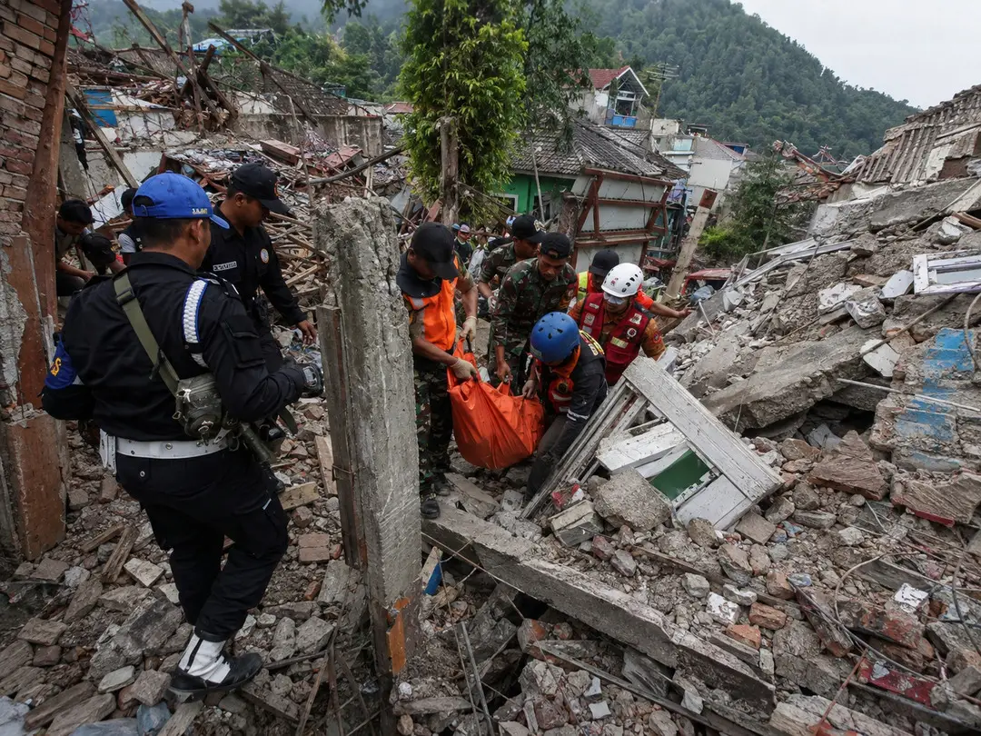
Two powerful earthquakes struck different parts of Indonesia within hours on Saturday, turning an already deadly day into a wider test of the country’s disaster-response capacity. A magnitude 7.7 quake off Flores killed at least 40 people, while a second major earthquake later struck North Sumatra, underscoring how quickly seismic risk can shift across the vast archipelago.
What matters now is not simply that Indonesia experienced two strong earthquakes in one day. The immediate pressure is whether rescuers can reach communities cut off by landslides, damaged roads and communications failures before the human toll climbs further—a challenge similar to the access problems confronting crews after the recent Colombia earthquake emergency.
Indonesia Earthquake Disaster Has Become a Race for Access
The first and far more destructive earthquake struck near Flores early Saturday. The U.S. Geological Survey measured it at magnitude 7.7, with the epicenter about 68 kilometers north-northwest of Ende in East Nusa Tenggara. The shallow quake triggered building collapses, landslides and widespread panic.
By Saturday evening, rescuers had recovered at least 40 bodies, with dozens of people taken to hospitals. Earlier official figures had placed the toll at 38, illustrating how quickly casualty numbers can change while crews reach previously inaccessible areas. More than 2,000 residents in Nagekeo had also fled their homes.
That uncertainty is central to the crisis. Access is now the pressure point. Landslides have cut roads across Flores, including sections of the Trans-Flores highway, while power failures have disrupted communications between damaged communities and emergency authorities.
The latest casualty and rescue update showed teams struggling to reach Nagekeo, one of the areas closest to the epicenter, with some rescuers attempting to approach by ferry after road access became impossible.
A Second Major Quake Struck Hundreds of Miles Away
Hours later, another powerful earthquake struck North Sumatra. USGS measured the second event at magnitude 6.9, centered near Pematangsiantar at a depth of about 183 kilometers. Indonesian authorities issued no tsunami warning for that quake, and there were no immediate reports of major damage.
Crucially, the North Sumatra earthquake was geographically separate from the destructive Flores sequence. Calling every later tremor an aftershock would therefore misrepresent what happened. Indonesia experienced a deadly earthquake and its many aftershocks around Flores, then another significant earthquake in a different part of the country.
The second earthquake event data helps explain another key difference: depth. At more than 180 kilometers below the surface, the North Sumatra earthquake was much deeper than the shallow Flores event, reducing the intensity of surface shaking compared with what could occur from a similarly sized shallow rupture.
Magnitude alone does not determine damage. Depth, distance from populated areas, construction quality, soil conditions and the type of fault movement all shape what residents experience.
Distance Changed the Risk, but Not the Significance
A deeper earthquake can still be felt across a wide area because seismic energy travels through the crust and upper mantle before reaching the surface. In North Sumatra, that meant communities could experience noticeable shaking even without the concentrated destruction associated with a shallow rupture directly beneath populated areas.
Location also matters because Indonesia’s major cities, smaller towns and transportation corridors are spread across a vast and geologically active archipelago. Even when a quake does not produce widespread structural damage, it can trigger temporary evacuations, inspections and concern over bridges, schools, hospitals and other critical infrastructure.
Officials must also distinguish between felt shaking and damaging shaking when communicating risk. A strong magnitude can sound alarming on its own, but emergency response depends on where the energy was released, how long the shaking lasted and what vulnerabilities existed at the surface.
That distinction became especially important on a day when Indonesia was already responding to a deadly disaster in Flores. The second quake did not simply add another number to the seismic record; it forced authorities and residents to assess a separate threat while resources and public attention were already stretched.
Two Earthquakes Created Very Different Emergencies
Putting the two events side by side shows why the first quake produced a humanitarian emergency while the second, despite its considerable magnitude, initially appeared far less destructive.
| Earthquake | Magnitude | Location | Approximate depth | Immediate impact |
|---|---|---|---|---|
| Flores earthquake | 7.7 | North of Ende, East Nusa Tenggara | 10 km | Fatalities, collapsed buildings, landslides and tsunami |
| North Sumatra earthquake | 6.9 by USGS | Near Pematangsiantar | 183 km | No immediate major damage reported |
Those differences matter for residents following breaking earthquake alerts. Two events can have similar-looking magnitude numbers while presenting dramatically different risks at ground level.
Flores suffered the more dangerous combination: a very powerful, shallow offshore earthquake close enough to inhabited communities to damage structures and trigger landslides. North Sumatra’s deeper event generated widespread concern but initially lacked the same destructive footprint.
Tsunami Danger Passed but the Ground Crisis Did Not
Indonesia initially issued tsunami warnings following the Flores earthquake and residents moved toward higher ground. Coastal monitoring later allowed authorities to lift the warning, although measurable tsunami waves had reached several locations. AP reported waves as high as 1.61 meters in parts of East Manggarai.
A lifted tsunami warning can create the impression that the worst danger has ended. In Flores, that is not the case.
The emergency moved inland. Damaged buildings remain unstable, landslides continue to obstruct routes, utilities have been interrupted and some communities remain difficult to contact. Aftershocks add another hazard because structures weakened by the main earthquake can shift or collapse during additional shaking.
By Saturday afternoon, Indonesian authorities had recorded hundreds of aftershocks following the Flores event. Those tremors complicate both rescue work and decisions about when residents can safely return to damaged homes.
Indonesia’s Geography Makes Rescue Logistics Harder
Indonesia’s seismic vulnerability is well known. Its position along the Pacific Ring of Fire places large portions of the country near active plate boundaries, producing frequent earthquakes and volcanic activity. But geography creates a separate operational problem once a disaster occurs.
Flores is part of East Nusa Tenggara, a region spread across islands and mountainous terrain. When landslides block roads and communications fail, relief cannot simply move along an alternative highway. Boats, helicopters and specialized teams may become essential for reaching isolated communities.
Authorities deployed helicopters and a rescue vessel as efforts expanded. Logistics can determine survival when trapped residents are separated from rescue teams not merely by rubble but by damaged transportation networks and broken communications.
That makes the early death toll especially fluid. Areas currently reporting few casualties may simply be areas where assessment is incomplete, while hospitals and rescue agencies may reconcile figures differently as patients and bodies are moved.
Rescue Access and Aftershocks Are the Next Critical Signals
Several developments will show whether the Indonesia earthquake disaster is stabilizing or becoming more severe. The first is access to isolated villages. Reopened roads, restored communications and successful helicopter or maritime operations would allow rescuers to establish a clearer picture of casualties and structural damage.
Aftershock activity is the second major concern. Continued strong shaking could destabilize damaged buildings, trigger additional landslides and force search teams to pause operations. Residents returning too quickly to compromised structures would face the same danger.
Hospital capacity, electricity restoration and temporary shelter availability will also become increasingly important as the response moves beyond the first hours. Thousands of evacuated residents may need support even if their homes remain standing.
Indonesia’s second major earthquake on Saturday did not immediately produce the devastation seen in Flores, but its timing reinforced the country’s extraordinary exposure to seismic hazards. The next hours matter most in the communities already hit hardest.
For the Indonesia earthquake disaster, the decisive story is no longer the shock of two powerful tremors occurring on the same day. It is whether emergency crews can reach the places still cut off, find survivors beneath damaged structures and prevent a deadly earthquake from becoming an even larger humanitarian crisis.
Frequently asked questions
How many people have died in the Indonesia earthquake?
At least 40 people were confirmed dead following the powerful Flores earthquake, although the toll could change as rescue teams reach isolated communities and authorities complete damage assessments.
Were the two Indonesia earthquakes connected?
No. The second major earthquake struck near North Sumatra, far from the Flores earthquake zone. It was a separate seismic event rather than part of the Flores aftershock sequence.
Is there still a tsunami warning in Indonesia?
The tsunami warning issued after the Flores earthquake was later lifted. Attention has since shifted toward aftershocks, landslides, damaged buildings, disrupted roads and ongoing rescue operations.
Why was the Flores earthquake more destructive?
The Flores earthquake was both powerful and shallow, which can produce much stronger shaking at the surface. Its location also contributed to landslides, infrastructure damage and difficult rescue conditions.
Are aftershocks still a danger after the earthquake?
Yes. Strong aftershocks can further weaken damaged buildings, trigger additional landslides and interrupt rescue work. Residents in affected areas should continue following local emergency instructions and avoid unsafe structures.


